|
|
Transport
This page will shortly give details of how to get around to and from Shenley Brook End
Buses
What time is the next bus? Where does it run? Click on the following link for an excellent bus route finder for Milton Keynes: http://www.mkweb.co.uk/busroutes/
The following is a list of buses that serve Shenley Brook End
| 3 / 3E - Wolverton - City Centre - Shenley Church End |
| Wolverton Agora, Bradville Marlborough Roundabout, Great Linford St Ledger Drive, Neath Hill Local Centre, City Centre Food Centre [D4], City Centre The Point [L4], Central Bus Station [23], Central Railway Station [38], Great Holm Local Centre, Crownhill Watling Street, Crownhill Local Centre, Shenley Church End Fortescue Drive Rdbt. |
| 8 / 8A - Medbourne/Tattenhoe - City Centre - Bletchley |
| Medbourne Portway, Kingsmead Snelshall Street Bus Stop, Kingsmead Picton Street, Tattenhoe Winfold Lane, Westcroft District Centre, Shenley Brook End Fulmer Street, Knowl Hill Childs Way, Central Railway Station [34], Central Bus Station [21], City Centre The Point [L3], City Centre Food Centre [D3], Fox Milne Roundabout, Kingston District Centre, Browns Wood Elgar Grove, Walnut Tree Litchfield Down, Bletchley Bus Station. |
| 9 / 9A - Newport Pagnell - City Centre - Bletchley |
| Newport Pagnell, Market Hill, Wordsworth Avenue, Local Centre, Giffard Park, Knebworth Gate, Neath Hill, Local Centre, Downs Barn, Local Centre, City Centre, Food Centre [D4], City Centre, The Point [L4], Central Railway Station [38], Shenley Lodge, Meeting Place, Shenley Brook End, Cressey Avenue, Furzton, Blackmoor Gate / Dulverton Drive, Severn Way, Ribble Close, Bletchley, Bus Station. |
| 20 - Kingsmead - City Centre - Walnut Tree |
| Kingsmead Whaddon Road, Westcroft Wimbourne Crescent, Shenley Brook End Walbank Grove, Shenley Lodge Park, Shenley Church End Shenley Road, Loughton The Green, Central Bus Station [23], Central Railway Station [33], Elder Gate [25], City Centre The Point [L3], City Centre Food Centre [D3], Hospital Standing Way, Open University St Michaels Drive, Walnut Tree Litchfield Down, Browns Wood Elgar Grove, Wavendon Gate Fyfield Barrow, Walnut Tree Hindhead Knoll. |
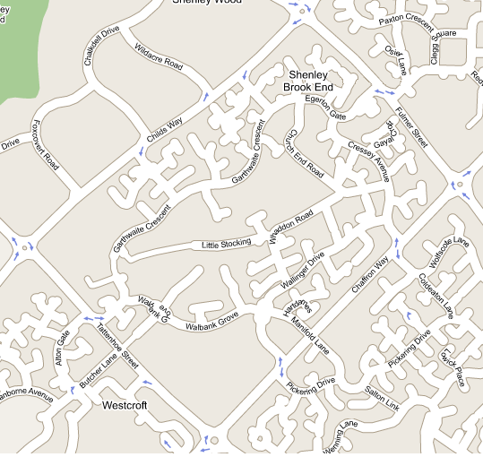
This map will soon show the location of bus stops and the route that the buses take around
Shenley Brook End
|
|